
ATLANTA — The 11Alive StormTrackers were busy with a severe weather outbreak across the South and Southeast that pushed a dangerous storms across the region through Sunday into early Monday morning.
Trees and powerlines were reported down across the region. Do you have damage in your area? Join the 11Alive StormTrackers Facebook page and upload your photos, video and stories.
Scroll down for details.
Monday, April 13
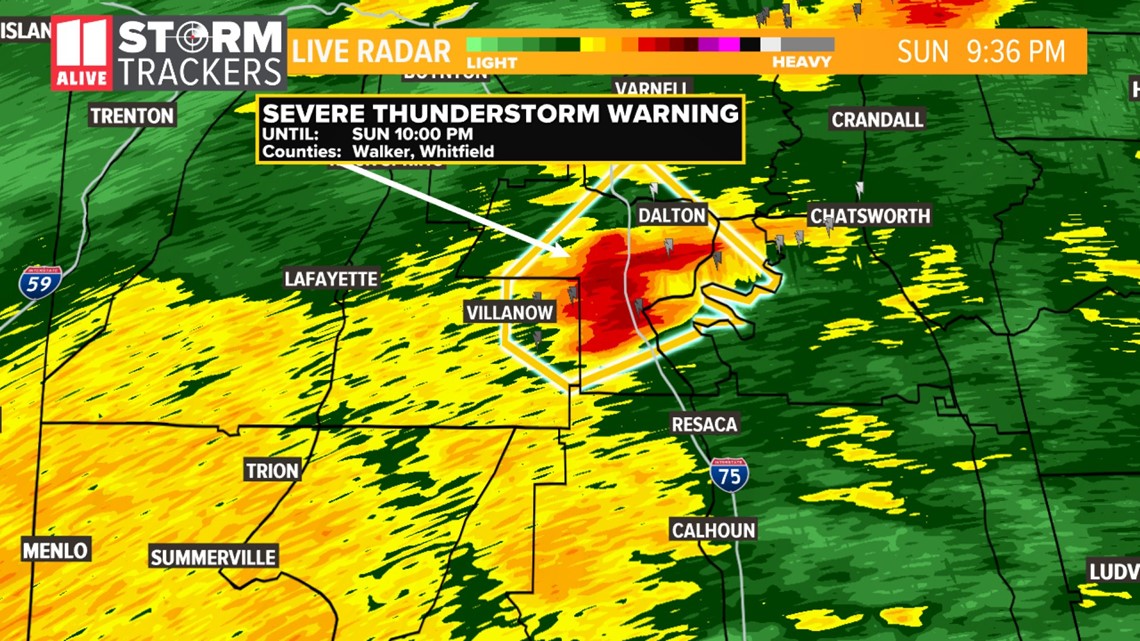
11 a.m. | The City of Dalton Fire rescue shared a stern warning for citizens: TURN AROUND, DON'T DROWN. They said someone attempted to drive around barricades at around 7:00 a.m. Rescuers had to pull the driver from a vehicle after attempting to drive through flood waters covering Willowdale Road near Highway 41.
9:30 a.m. | Images show how powerful the storm was. In Upson County, a house was lifted from the foundation and pushed into the highway.
8 a.m. | Gov. Brian Kemp took to Twitter with this message: This morning, several communities are grappling with serious storm damage, and I ask everyone to lift them up in prayer. Our hearts go out to the loved ones and friends of those we lost.
6:33 a.m. | Officials said a home is in the middle of the road in Thomaston.
6:09 am | Authorities in Murray County confirm five people died after storms hit a mobile home park at State Road 225 and Redcut Road in Chatsworth.
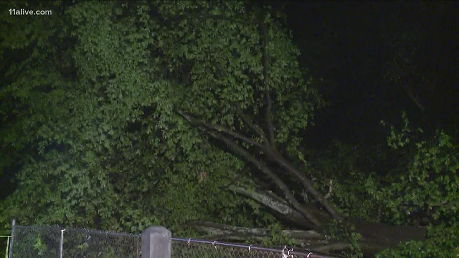
5:47 am | Officials report one person is dead after a tree fell on their Cartersville home.
5:40 am | Downed trees fell on three cars in East Point
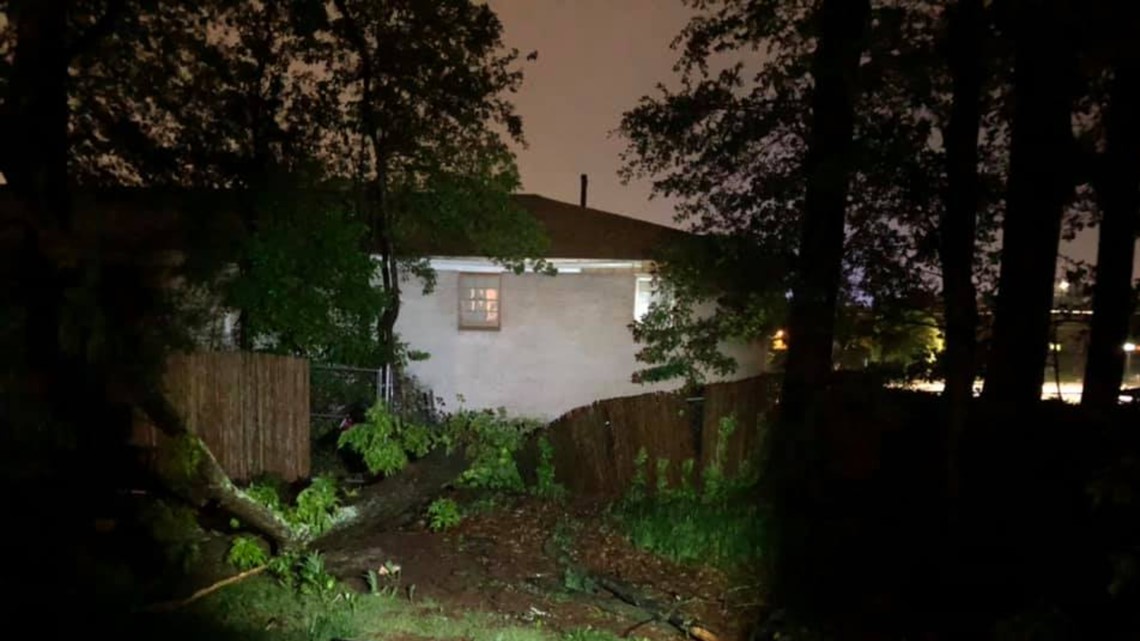
5:30 am | Nick shares more local storm damage. The people inside were able to escape through the back door.
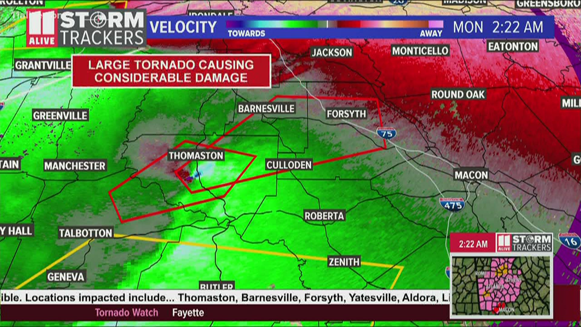
5:10 am | Scary velocity image, shared by Meteorologist Wes Peery.
5:05 am | Wind advisory in effect until 10 a.m. today.
5:00 am | Tornado watch remains in effect near the Athens area until 7:00 a.m.
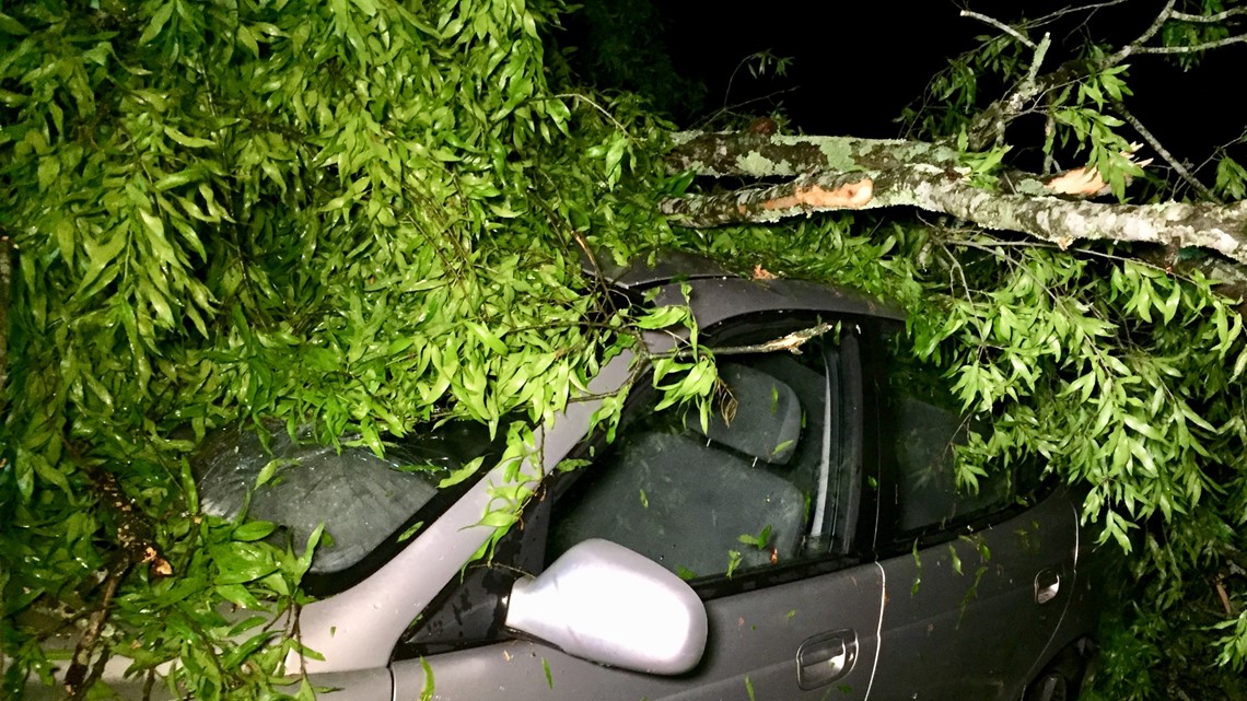
4:40 am| Viewer Savannah Leecroy's says her car is crushed. She is pregnant and is due in a week. Now, she has no car.

3:57 am | Viewer Victoria Snyder-Hernandez said she is safe after a tree fell in her yard in the area of Virginia Avenue in College Park. She said the tree, about 40 to 50 feet tall, fell near her family's chicken coop.

3:51 am | A Severe Thunderstorm Warning has been issued for Glascock, Greene, Hancock, Taliaferro, Warren and Wilkes counties until 4:30 a.m.
3:45 am | The tornado warning for Putnam County has been canceled but continues for Greene and Hancock counties until 4 a.m.
3:44 am | The Severe Thunderstorm Warning for Baldwin, Hancock, Johnson, Laurens, Twiggs, Washington and Wilkinson counties until 4:15 a.m.
3:40 am | The Severe Thunderstorm Warning for Banks, Jackson and Madison has expired.
3:38 am | The Severe Thunderstorm Warning for Greene, Jasper, Morgan and Oconee counties has expired.
3:28 am | A Tornado Warning for Greene, Hancock and Putnam counties has been continued until 4 a.m. Authorities are reporting an observed tornado in the area. At 3:24, severe thunderstorms capable of producing a tornado were located near Eatonton. Another circulation was located near Resseaus Crossroads, moving northeast at 50 mph.
3:25 am | A Severe Thunderstorm Warning has expired for Bibb, Butts, Crawford, Jasper, Jones and Monroe counties.
3:24 am | The Tornado Watch for much of west and north Georgia has expired though many counties west of Atlanta remain under the watch. The latest watch continues for Clayton, Dawson, DeKalb, Fayette, Forsyth, Fulton, Lumpkin, Towns, White, Chattahoochee, Coweta, Lamar, Meriwether, Muscogee, Pike, Spalding, Talbot and Upson counties.
3:20 am | Tornado Warning canceled for Jones County but continues for Putnam County until 3:30 a.m.
3:19 am | The Severe Thunderstorm Warning for Barrow and Hall counties has been canceled but continues for Banks, Jackson and Madison until 3:45 a.m.
3:15 am | The Severe Thunderstorm Warning has been canceled Newton and Walton counties but continues for Greene, Jasper, Morgan and Oconee counties until 3:45 a.m.
3:14 am | A Severe Thunderstorm Warning has been canceled for Baldwin and Jasper counties however it continues for Jones and Putnam counties until 3:30 a.m.
3:14 am | Severe Thunderstorm Warning canceled for DeKalb and Gwinnett counties but continues for Newton, Rockdale and Walton counties until 3:30 a.m.
3:13 am | The Severe Thunderstorm Warning for Crawford and Monroe counties has been canceled but continues for Baldwin, Bibb, Houston, Jasper, Jones, Peach, Putnam, Twiggs and Wilkinson counties until 3:45 a.m.
3:10 am | The National Weather Service has canceled a Tornado Warning for Habersham County but it continues for Stephens and Franklin counties in Georgia and Oconee County in South Carolina.
3:07 am | Tornado Warning expires for Butts, Jasper, Jones and Monroe counties.
3:06 am | Tornado Warning issued for Baldwin, Jasper, Jones and Putnam counties until 3:30 a.m.
3:04 am | Tornado Warning issued for Franklin, Habersham and Stephens County, Georgia and Oconee County, South Carolina until 3:30 a.m.
3:01 am | Severe Thunderstorm Warning for Banks, Barrow, Hall, Jackson, and Madison until 3:45 a.m.
2:59 am | A Severe Thunderstorm Warning has been issued for Greene, Jasper, Morgan, Newton, Oconee and Walton counties until 3:45 a.m.
2:56 am | Severe Thunderstorm Warning issued for Baldwin, Bibb, Crawford, Houston, Jasper, Jones, Monroe, Peach, Putnam, Twiggs and Wilkinson counties until 3:45 a.m.
2:54 am | Severe Thunderstorm Warning expired for Clayton, Fayette and Fulton counties.
2:47 am | Tornado Warning issued for DeKalb and Fulton until 3 a.m.
2:46 am | Tornado Warning in effect for Butts, Jasper, Jones and Monroe counties until 3:15 a.m.
2:38 am | "Observed tornado" seen over the College Park near Hartsfield-Jackson International Airport.
2:34 am | A Tornado Warning has been issued for southern Fulton County and parts of Clayton County until 2:45 a.m.
2:31 am | A Severe Thunderstorm Warning for Cherokee and Pickens counties has been canceled but continues for Banks, Dawson, Forsyth, Hall, Lumpkin and WHite until 2:45 a.m.
2:25 am | The National Weather Service now classifies a storm that crossed through the area of Lincoln Park - in the Thomaston area - as a "large and extremely dangerous tornado" that moved northeast in the area at about 70 mph.
2:24 am | A Severe Thunderstorm Warning has been issued for Clayton, Coweta, Fayette and Fulton counties until 3 a.m.
2:22 am | A Severe Thunderstorm Warning has been issued for Bankes, Barrow, Cherokee, Cobb, DeKalb, Forsyth, Fulton, Gwinnett, Hall and Jackson counties.
2:20 am | A Tornado Warning has now been issued for Lamar, Monroe and Upson counties until 2:45 a.m. with a damage threat considered "considerable"
2:15 am | The Tornado Warning for Talbot and Upson counties has been continued until 2:30 a.m.The borders of the warning are moving further into the Upson County area.
2:14 am | The Severe Thunderstorm Warning has been canceled for Douglas and Paulding County but continues fo Carroll, Coweta, Fulton and Heard counties until 2:30 a.m.
2:11 am | A Severe Thunderstorm Warning has been continued for Carroll, Coweta, Douglas, Fulton, Heard and Paulding until 2:30 a.m.
2:04 am | A Severe Thunderstorm Warning continues for Fannin, Lumpkin, Towns, Union and White counties until 2:15 a.m.
2:04 am | The National Weather Service has canceled a Severe Thunderstorm for Harris, Meriwether and Troup counties.
2:03 am | A Severe Thunderstorm Warning has been canceled for Haralson County but continues for Carroll, Coweta, Douglas, Fulton , Heard and Paulding counties.
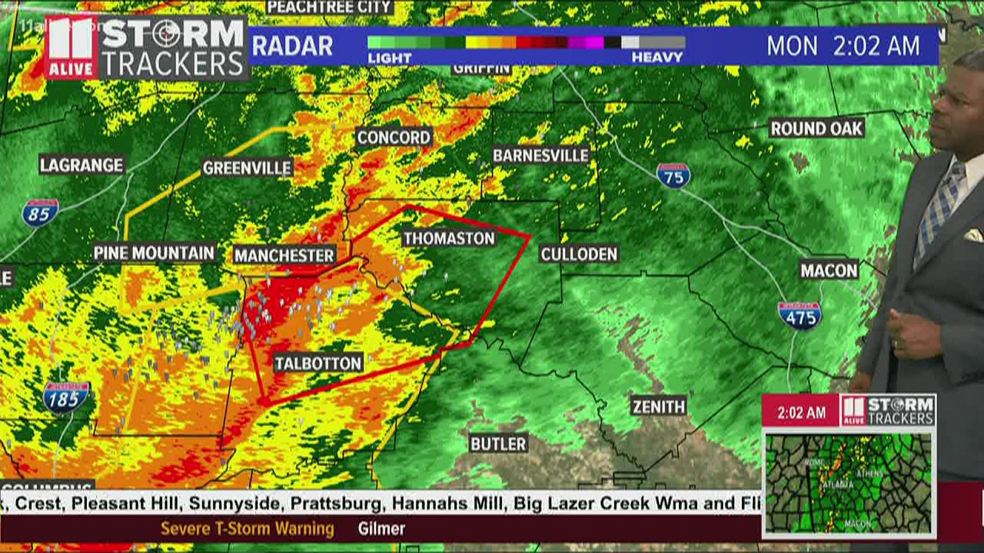
2:02 am | A Tornado Warning has been issued for Upson and Talbot counties until 2:30 p.m.
1:59 am | The Tornado Warning for Cherokee County has been canceled.
1:46 am | A Tornado Warning has been issued for Cherokee County until 2:15 a.m.
1:44 am | The Severe Thunderstorm Warning for Bartow, Cherokee, Cobb, Haralson, Paulding and Polk continues until 2:15 a.m. but has been canceled for Gordon County.
1:43 am | A Severe Thunderstorm Warning has been issued for Carroll, Coweta, Douglas, Fulton, Haralson, Heard and Paulding counties until 2:30 a.m.
1:36 am | The Severe Thunderstorm Warning has been continued for Fannin, Gilmer, Lumpkin, Towns, Union and White counties until 2:15 a.m.
1:26 am | A Severe Thunderstorm Warning for Fannin, Gilmer, Lumpkin, Towns, Union and White counties will continue until 2:15 a.m.
1:25 am | The Tornado Warning for Cherokee County has been canceled but continues for Bartow County until 1:30 a.m.
1:24 am | A Severe Thunderstorm Warning has been issued for Meriwether, Troup and Harris counties until 2:15 a.m.
1:23 am | A Severe Thunderstorm Warning has been issued for Fannin, Gilmer, Lumpkin, Towns, Union and White until 2:15 a.m.
1:22 am | A Severe Thunderstorm Warning has been continued for Bartow, Cherokee, Cobb, Gordon, Haralson, Paulding and Polk counties until 2:15 a.m.
1:200 am | The Tornado Warning has been canceled for Gordon and Pickens counties but continues for Dawson and Gilmer until 1:30 a.m.
1:11 am | A tornado warning has been issued for Dawson, Gilmer, Gordon and Pickens counties until 1:30 a.m.
1:05 am | A tornado warning has been issued for Bartow and parts of west Cherokee counties, moving NE towards Cartersville at 40MPH. It's in effect until 1:30 a.m.
12:55 am | A Severe Thunderstorm Warning has been issued for Bartow, Cherokee, Cobb, Floyd, Gordon, Haralson, Paulding and Polk counties until 2:15 a.m.
12:46 am | A Severe Thunderstorm Warning has been continued for Bartow, Floyd, Gordon, Haralson, Paulding and Polk counties until 1 a.m.
12:43 am | The Tornado Watch for Catoosa, Chattooga and Walker counties has been canceled.
12:37 am | A Severe Thunderstorm Warning continues for Bartow, Floyd, Gordon, Haralson, Paulding and Polk until 1 a.m. The warning is canceled for Chattooga County.
12:30 am | Brittney Duncan sent this photo of the Atlanta Skyline to 11Alive. The most severe part of the storm hasn't yet moved through the city, but her photo shows the cloud-cover reflecting city light.


12:34 am | A Severe Thunderstorm Warning continues for Chattooga, Fannin, Floyd, Gilmer, Gordon, Murray, Walker and Whitfield counties until 1:15 a.m. The warning is canceled for Catoosa County.
12:24 am | A Severe Thunderstorm Warning has been issued for Catoosa, Chattooga, Fannin, Floyd, Gilmer, Gordon Murray, Walker and Whitfield counties until 1:15 a.m.
12:15 am | The Tornado Warning for Chattooga County has expired.
12:08 am | A Severe Thunderstorm Warning has been issued for Catoosa, Chattooga, Fannin, Floyd, Gilmer, Gordon, Murray, Walker and Whitfield counties until 1:15 a.m.
12:07 am | A Severe Thunderstorm Warning has been issued for Bartow, Chattooga, Floyd, Gordon, Haralson, Paulding and Polk counties until 1 a.m.
12:04 am | A Severe Thunderstorm Warning has been issued for Bartow, Chattooga, Floyd, Gordon, Haralson, Paulding and Polk counties until 1 a.m.
Sunday, April 12
11:55 pm | Tornado warning canceled for Floyd County but continues until 12:15 p.m. for Chattooga County.
11:50 pm | A Tornado Watch has been issued for numerous counties across north Georgia until 7 a.m. Counties in the Tornado Watch include Cherokee, Dawson, Fannin, Gilmer, Pickens, Bartow, Catoosa, Chattooga, Floyd, Gordon, Murray, Polk, Walker, Whitfield Baldwin, Bib, Butts, Crawford, Crisp, Dooly, Houston, Jasper, Jones, Monroe, Peach, Putnam, Twiggs, Wilkinson, Barrow, Clayton, Cobb, DeKalb, Douglas, Fayette, Forsyth, Fulton, Gwinnett, Hall Henry, Lumpkin, Morgan, Newton, Rockdale, Union, Walton, Banks, Clarke, Jackson, Madison, Oconee, Oglethorpe, Towns, White, Carroll, Haralson, Paulding, Chattahoochee, Coweta, Harris, Heard, Lamar, Macon, Marion, Meriwether, Muscogee, Pike, Schley, Spalding, Stewart, Sumter, Talbot, Taylor, Troup, Upson and Webster counties.
11:40 pm | A tornado warning has been issued for Chattooga and Floyd counties until 12:15 a.m.
11:27 pm | A Severe Thunderstorm Warning has been issued for Catoosa, Chattooga, Floyd, Gordon, Murray, Walker and Whitfield counties until 12:15 a.m.
11:20 pm | Tornado Warning issued for Catoosa County until 11:30 p.m.
10:31 pm | The Tornado Watch for Bartow, Catoosa, Chattooga, Cherokee, Dawson, Fannin, Floyd, Gilmer, Gordon, Murray, Pickens, Polk, Walker and Whitfield counties has been extended until 1 a.m.
10:07 pm | Tornado warning canceled for Murray County.
10:02 pm | The Tornado Watch for Whitfield County has been canceled but continues for Murray County until 10:30 p.m.
9:59 pm | A Tornado Watch for Murray and Whitfield counties has been continued until 10:30 p.m.
9:55 pm | Georgia Power reports more than 6,100 customers without power in the state. The majority of those cases are in northwest Georgia. The Georgia Electric Membership Cooperative also reports more than 9,500 customers without power. The majority of those are in north Georgia.
9:51 pm | Even as much of the weather hits northwestern Georgia, the impact is being felt in Atlanta as well wit ha tree down at 1661 Brewer Blvd. SW The tree has taken lines down. There are no reports of injuries. Georgia Power has been notified. There is also a report of a tree down blocking the road at the intersection of Hosea L. Williams Drive and Carter Avenue. No injuries reported.
9:48 pm | Severe Thunderstorm Warning canceled for Murray but continues for Whitfield County until 10:15 p.m.
9:40 pm | A Severe Thunderstorm Warning has been issued for Murray and Whitfield counties until 10:15 p.m.

9:26 pm | A Flash Flood warning has been issued for Catoosa, Chattooga, Dade, Fannin, Floyd, Gilmer, Gordon, Murray, Walker and Whitfield counties until 3:30 a.m. Rainfall totals are expected to range from three to six inches.
9:23 pm | Severe Thunderstorm warning expired for Chattooga County.
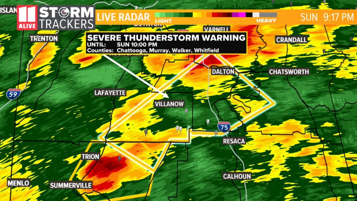
9:15 pm | Severe thunderstorm warning issued for Chattooga, Murray, Walker and Whitfield counties until 10 p.m.

8:59 pm | A Tornado Watch has been issued for Rabun County until 2 a.m.
8:49 pm | The Tornado Warning has been dropped for Chattooga County but continues for Murray and Whitfield until 9:15 p.m.
8:29 p.m. | Amateur radio reports a tornado. Several reports of trees down and possible structural damage along Highway 151 south of LaFayette in southern Walker County. A tornadic debris signature was seen on radar in this location.
7:48 pm | Tornado warning issued for Chattooga, Floyd and Walker counties until 8:30 p.m.
7:47 pm | A Severe Thunderstorm Warning has been issued for northeastern Floyd County, southeastern Walker County and Chattooga County until 8:30 p.m.
The national weather service spotted a severe thunderstorm near Sand Rock - about seven miles southwest of Little River Canyon National Preserve, moving northeast at 45 mph.
Hazards include 60 mph wind gusts and damage to roofs, siding and trees.
7:18 pm | A Tornado Watch has been issued for several north Georgia and metro Atlanta counties until 11 p.m. Counties under the watch include Bartow, Catoosa, Chattooga, Cherokee, Dawson, Fannin, Floyd, Gilmer, Gordon, Murray, Pickens, Polk, Walker and Whitfield according to the National Weather Service.
5:48 pm | The Tornado Watch issued for parts of Alabama, including Cleburne County, Ala., has been upgraded to a PDS (Particularly Dangerous Situation) Tornado Watch -- and extended until midnight Central Time (1 am Eastern Time).
Threats for the upgraded watch include numerous tornadoes with a few intense tornadoes likely; Widespread large hail and very large hail events to 3 inches in diameter likely; Widespread damaging wind gusts to 70 mph likely.
Stay with the 11Alive StormTrackers and 11Alive.com all evening for the latest information as it becomes available.
5:35 pm | Pickens County officials said they will be practicing social distancing in their shelter during tonight's severe weather by setting up separate areas for each family.
"We will also have hand sanitizer and sanitizer spray," said Phillip Dean, Pickens County EMA Director.
The Pickens County shelter is in the basement of the Pickens County Administration Building, 1266 East Church Street in Jasper.
5:25 pm | Dawson County Fire and Emergency officials said they are opening emergency shelters at Rock Creek Park at 8 pm.
Anyone seeking refuge will be required to wear a mask and maintain 6 feet of separation. Disinfectants will also be provided to keep citizens and the facility safe.
Anyone who has exhibited COVID-19 symptoms within the past 72 hours or who has been in contact with anyone with COVID-19 will be provided with alternate accommodations in the Rock Creek Park Recreation Center, officials said.
4:30 pm | A Tornado Watch has been issued for much of northern Alabama, including Cleburne County, Ala., until 10 pm, Central Time.
Primary threats include: Several tornadoes with some intense tornadoes likely. Widespread damaging winds and isolated significant wind gusts to 80 mph are likely; Isolated very large hail events up to 2 inches in diameter are possible.
Stay with the 11Alive StormTrackers and 11Alive.com all evening for the latest information as it becomes available.
10:54 am | A Flash Flood Watch has been issued for the far northern counties of Georgia, primarily north of a Rome-to-Dawsonville-to-Cleveland line, from 5 pm Sunday to 8 am Monday.
This includes Dade, Walker, Catoosa, Whitfield, Murray, Fannin, Gilmer, Union, Towns, Chattooga, Gordon, Pickens, Dawson, Lumpkin, White, and Floyd counties.
According to Wes, this is in advance of the expected heavy rainfall from tonight's storms.
10:22 am | A Wind Advisory has been issued for the entire metro Atlanta area and much of north Georgia for Sunday night through Monday morning at 6 am for non-thunderstorm winds gusting up to 35-to-40 mph.
Remember to disable "Do Not Disturb" mode on your phone so wireless weather alerts can wake you up in case a warning is issued for your area.
If you have not done so yet, download the 11Alive app for your smartphone for your Apple or Android device and make sure alerts are enabled.
A NOAA Weather Radio will also provide weather alerts for your area.
Please continue to check for forecast updates regularly on 11Alive and 11alive.com.
SEVERE WEATHER PREPARATIONS |