
ATLANTA — 11Alive meteorologist Wes Peery says the upcoming week will bring more nasty weather in at least a partial duplicate of this past week's heavy rains and strong storms followed by a deep freeze.
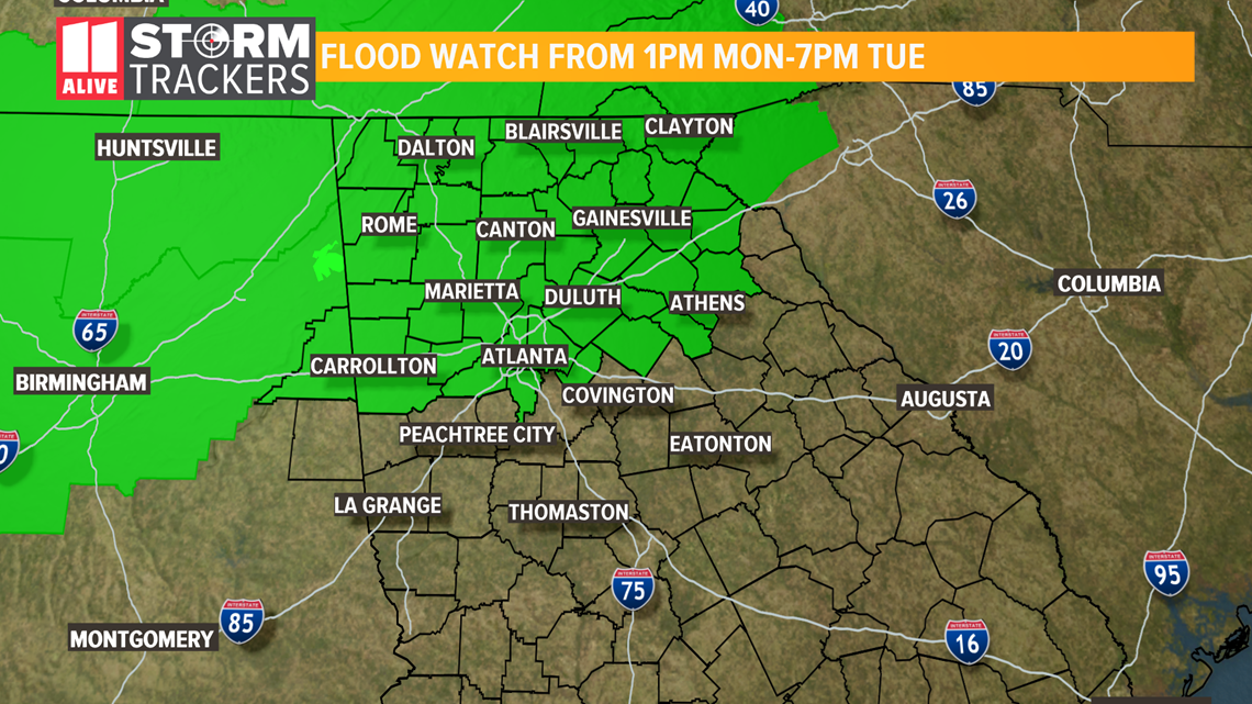
In advance of it all, the National Weather Service has already issued a Flood Watch for parts of north Georgia from Monday afternoon through Tuesday evening.
The flood watch is in effect for Dade, Walker, Catoosa, Whitfield, Murray, Fannin, Gilmer, Union, Towns, Chattooga, Gordon, Pickens, Dawson, Lumpkin, White, Floyd, Bartow, Cherokee, Forsyth, Hall, Banks, Jackson, Madison, Polk, Paulding, Cobb, Fulton, Gwinnett, Barrow, Clarke, Oconee, Haralson, Carroll, Douglas, DeKalb, Rockdale, Walton and Clayton counties, and includes the city of Atlanta.
Several waves of moderate to heavy rain are expected to begin Monday afternoon and persist for much of the week.
Flooding could occur in low-lying areas, rivers, small creeks and streams. The flooding could continue well after the rain stops in these areas.

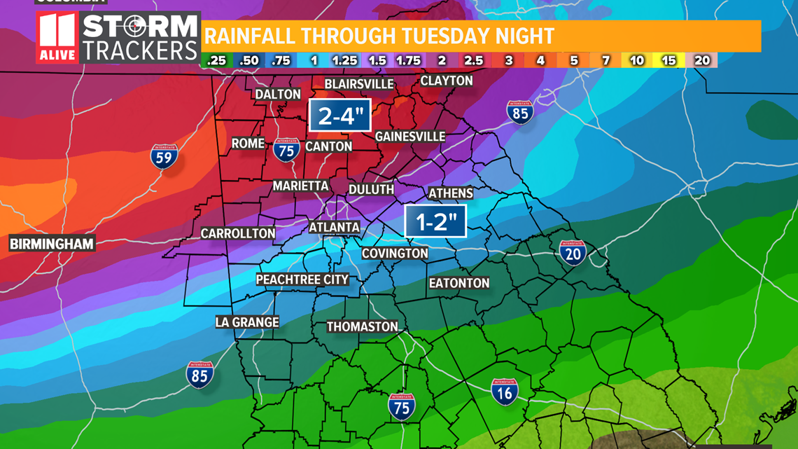
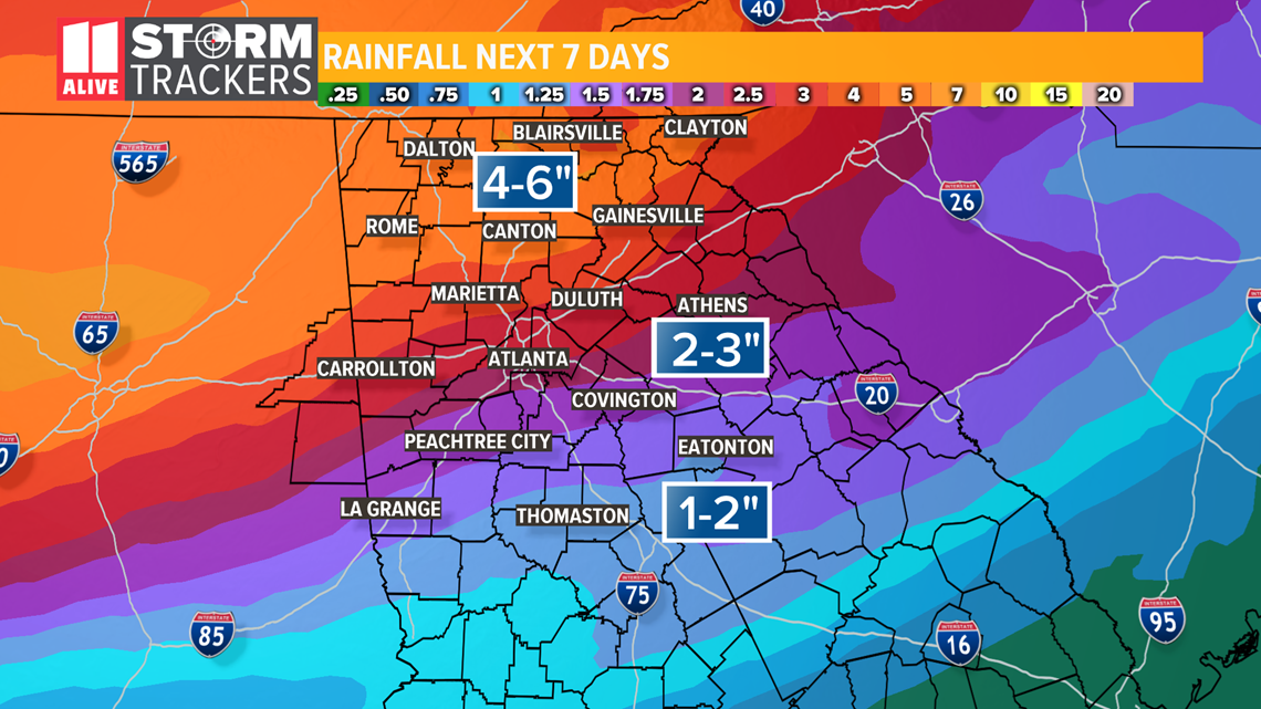
The early part of the week is likely to bring about 2 inches of rainfall across much of metro Atlanta with higher rainfall amounts to the north and somewhat lesser amounts to our south.
According to Wes, parts of the north Georgia mountains could see heavier rainfall amounts in the 2-to-4 inch range through Tuesday night, while areas to the south of Atlanta could get away with rainfall amounts in the 1-to-2 inch range.

Then, comes part two of this multi-part weather event.
Strong to severe storms are expected to come through Georgia and metro Atlanta Wednesday night and Thursday morning.
As of this point, our area is under a Level 2 threat for severe weather, with an even stronger Level 3 threat for our neighbors to the west in Alabama.

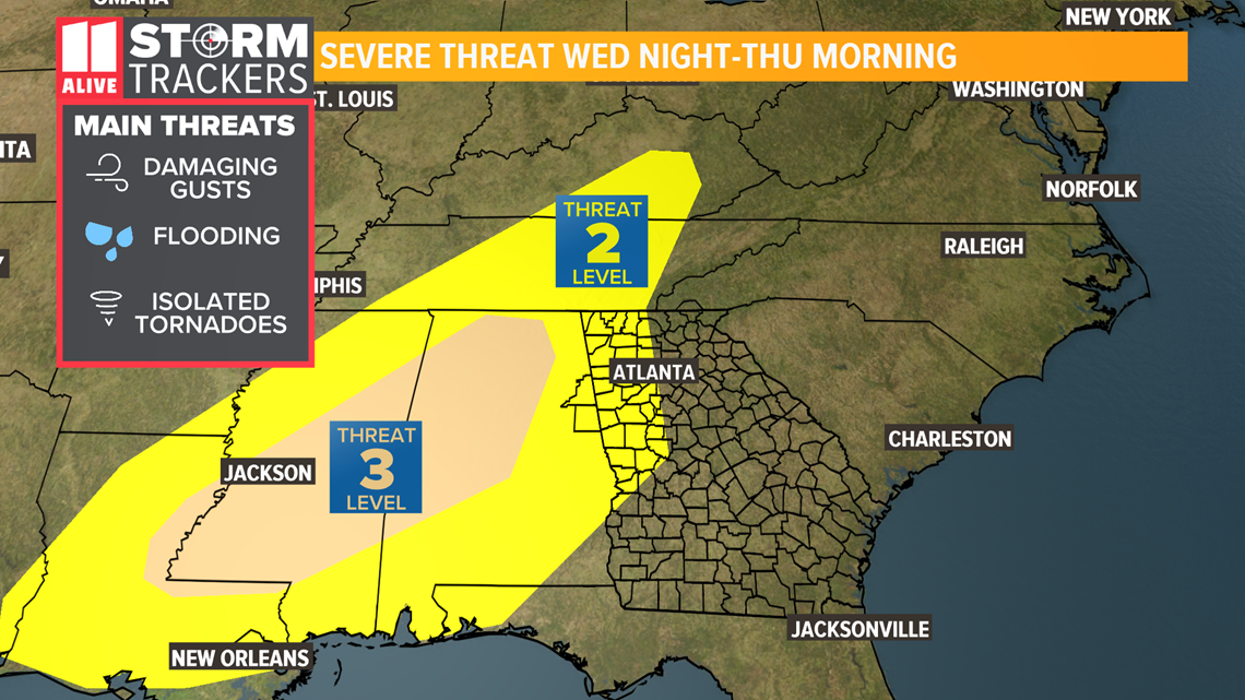
The primary threats from these storms include damaging wind gusts, torrential flooding rainfall amounts and isolated tornadoes.
As a result, over the next seven days, total rainfall amounts could top 3-to-4 inches in Atlanta, with even higher rainfall amounts to the north, where 4-to-6 inch rainfall totals are not out of the question.

Wes says that the severe weather event is coming in ahead of a strong cold front, which is expected to make its way into Georgia by Friday, bringing with it colder temperatures and the possibility of -- you guessed it, freezing temperatures and maybe even snow.
The 11Alive Storm Trackers will be monitoring this multi-day weather event as it moves closer to Atlanta and fine-tuning the forecast and its effects on our day-to-day climate over the course of this week.
Stay with 11Alive and 11Alive.com for the latest updates and any additional weather advisories or warnings as they are issued.
POWER OUTAGES CHECK | Georgia Power customers, check here. Georgia EMC customers check here.
RELATED STORIES |