ATLANTA — Strong and potentially severe storms moved across the Peach State Wednesday evening.
Following Tuesday's marathon of rain, forecasters said Wednesday's weather would come with a heightened threat of severe weather which could include damaging winds, hail and isolated tornadoes.
11Alive StormTrackers monitored conditions throughout the evening. Here's a look at those updates.
Weather updates:
Thursday, April 7, 2022
1:13 a.m. | A flash flood warning has been issued for portions of Clayton, Fayette, Henry, Newton, and Rockdale counties until 6:15 a.m.
Wednesday, April 6, 2022
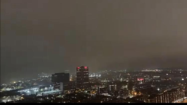
11:17 p.m. | It is pouring rain at the 11Alive station as storms roll into the metro.
10:53 p.m. | A Severe Thunderstorm Warning has been issued in Fulton, Douglas and Cobb counties until 11:15 p.m.
10:37 p.m. | A line of strong storms is making its way into the Atlanta metro, producing winds up to 40 mph and frequent lightning.
10:05 p.m. | A Tornado Watch for parts of north Georgia, including Murray, Whitfield, Gordon and Fanin counties has expired.
9:33 p.m. | A Tornado Watch is in effect for Ben Hill, Berrien, Brooks, Colquitt, Cook, Dougherty, Grady, Irwin, Lanier, Lee, Lowndes, Mitchell, Terrell, Thomas, Tift, Turner and Worth counties until midnight.
8:46 p.m. | A Severe Thunderstorm Warning has been issued for Pickens, Dawson and Gilmer counties until 9:15 p.m.
8:19 p.m. | A Severe Thunderstorm Warning has been issued for Murray, Gordon, Gilmer and Whitfield counties until 8:45 p.m.
8:13 p.m. | Northwest Georgia has seen close to 200 lightning strikes within a 15 minutes period as storms continue to affect several parts of the Peach State.
7:56 p.m. | A large number of counties were removed from the National Weather Service's Tornado Watch on the southside of the metro. A Tornado Watch still remains in effect for many counties in north and south Georgia until 10 p.m.
7:41 p.m. | Strong thunderstorms will impact portions of western Laurens, southern Wilkinson, northwestern Dodge, central Pulaski, southeastern Twiggs and Bleckley Counties through 8:15 p.m., the National Weather Service said.
7:20 p.m. | Several dirt roads in Lamar County are washing out as a result of the storms, according to the local sheriff's office.
6:59 p.m. | A Severe Thunderstorm Warning is in effect for Bibb, Macon, Houston, Peach and Twiggs counties until 7:45 p.m.
6:18 p.m. | A Flash Flood Warning is in effect for Bibb, Houston, Upson, Lamar, Monroe, Peach, Talbot, Crawford, Butts and Taylor counties until 11:15 p.m.
6:08 p.m. | A storm moving east over Summerville is producing hail and strong winds as it approaches Chattooga, Floyd and Walker counties.
5:55 p.m. | And moving back farther to the south, Upson County seeing strong storms:
5:55 p.m. | Severe Thunderstorm Warning issued for Dade County up in northwest Georgia.
5:45 p.m. | If you're on the southside, chances are you've seen some lightning in the last few minutes!
5:40 p.m. | A flood watch in central Georgia was expanded to include some counties closer to metro Atlanta, including Butts, Meriwether, Pike, Lamar and Troup. Jasper, Morgan, Greene, Oglethorpe also in it.
5:30 p.m. | Latest look at radar developments:
5:20 p.m. | Some unconfirmed reports of larger hail in Jasper County.
5:10 p.m. | Some additional info on that last tornado watch for north Georgia. It will be in effect until 10 p.m.
5:00 p.m. | Tornado watch issued for Dade, Walker, Chattooga, Catoosa, Murray, Whitfield, Gordon, Gilmer and Fannin counties.
5:00 p.m. | Something to keep an eye on in northwest Georgia:
4:55 p.m. | A Severe Thunderstorm Warning has been issued for Jasper and Putnam counties, as well as Jones.
4:50 p.m. | Reminder as there's sure to be plenty of street-surface flooding around the city:
4:20 p.m. | Storms coming over our area around now:
4:10 p.m. | Again, just outside our zone, but our friends down in Macon now have a Severe Thunderstorm Warning that was just issued through 5 p.m., as well as Crawford and Monroe counties.
3:55 p.m. | If you check out the future radar projection at 11alive.com/radar (the option for future is in the bottom left of the interface), you can see that some heavy rain is going to move over the city of Atlanta in the next half hour or so, and probably take 30-40 minutes to pass over us.
3:30 p.m. | Peering down south and keeping in mind southeast Georgia and the Macon area got hit harder yesterday, a tornado warning was issued for Crisp and Sumter counties, both southeast of Columbus.
3:25 p.m. | Not rising to the level of a warning, but a special weather statement was issued for strong thunderstorms in Carroll, Douglas and south Fulton counties until 4 p.m.
3:15 p.m. | A flood watch was issued that includes some counties in our zone: Greene, Jasper, Lamar, Morgan, Putnam, Oglethorpe and Upson.
3:00 p.m. | Here's some of the latest updates from 11Alive Meteorologist Nicole Hartford as storms are expected to start picking up in south metro Atlanta over the next hour or so:
2:15 p.m. | Gov. Brian Kemp tweeted he has declared a State of Emergency due to the storm damage from yesterday, which hit southeast Georgia particularly hard.
1:35 p.m. | A tornado watch has been issued for south metro Atlanta, including Clayton, Fayette, Coweta, Heard, Henry, Butts, Newton, Troup, Jasper, Greene, Lamar, Meriwether, Morgan, Pike, Spalding, Putnam and Upson counties.
MORE FROM THE 11ALIVE STORMTRACKERS
DOWNLOAD THE 11ALIVE APP:
Set up weather notifications by clicking the Gear icon in the upper right corner of the app. Select Notification -> Notification Settings -> Severe Weather Alerts -> Toggle the Severe Weather Alerts button to the right to turn alerts on.
Send photos and videos through the app by selecting the Near Me feature on the bottom right task bar of the app and entering your information.
TEXT YOUR WEATHER PHOTOS TO US: 404-885-7600
JOIN THE 11ALIVE STORMTRACKERS FACEBOOK GROUP: Nearly 10,000 metro Atlanta and north Georgia weather enthusiasts share their weather photos every day. Click here to join the group!