ATLANTA — Last weekend we were setting record high temperatures in Atlanta. Now as we prepare to "spring forward," the forecast for north Georgia is nothing resembling spring.
We are tracking the possibility of snow for part of north Georgia, as well as an incoming cold blast.
Three things to know
- As cold air rushes in, far north Georgia will see a changeover from rain to a brief window with snow showers and flurries early Saturday morning. Light accumulations are possible in the Winter Weather Advisory.
- Saturday afternoon's temperatures will be stuck in the low 40s with wind chills in the 20s in metro Atlanta.
- On Sunday morning, a deep freeze will unfold across all of north Georgia. These will be our coldest temperatures of the season so far. Atlanta will get down to the low to mid 20s. 10s are likely in the mountains. Tender blooms on flowering spring plants will be killed by this cold.
Here's Who Will See Snow
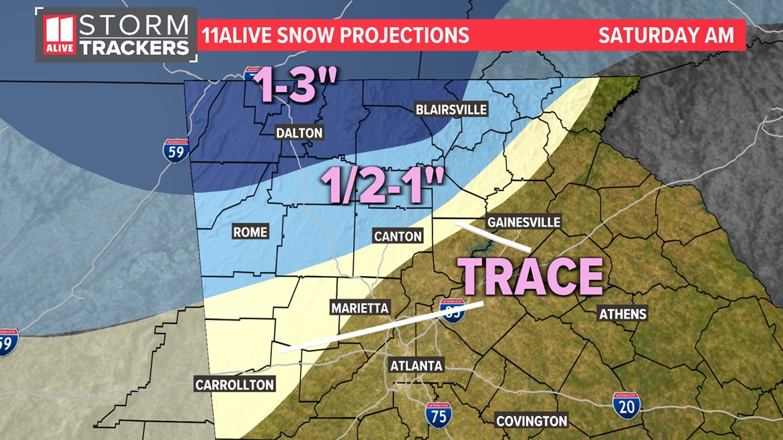
Light accumulations of snow are possible in northwest metro counties on grassy and elevated surfaces. Up to three inches of snow is possible in higher elevations in counties bordering Tennessee.
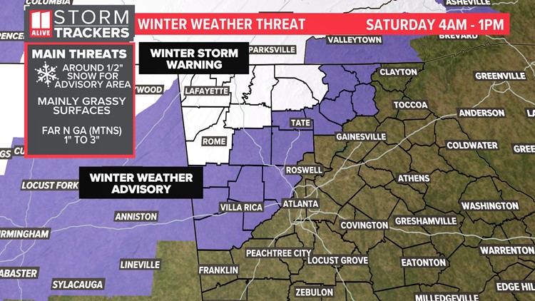
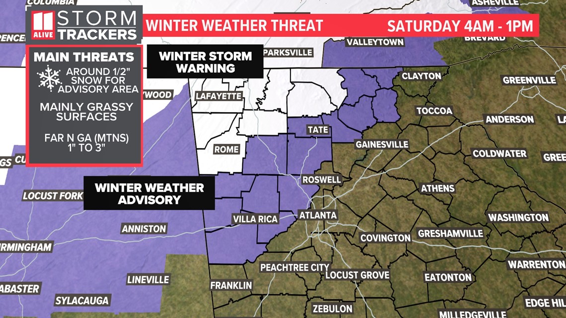
A Winter Storm Warning is in effect from 4 a.m. to 1 p.m. Saturday for the following North Georgia counties: Bartow, Chattooga, Catoosa, Gordon, Gilmer, Fannin, Floyd, Murray, Whitfield, Walker and Dade.
A Winter Weather Advisory is in effect from 4 a.m. to 1 p.m. Saturday for the following North Georgia counties: Carroll, Cherokee, Cobb, Dawson, Douglas, Haralson, Lumpkin, Paulding, Pickens, Polk, Towns, Union and White.

The changeover from rain to snow will happen overnight and the brief window of snow could lead to light accumulations. With warm temperatures and a lot of rain preceding the snow, much of what falls will initially melt on contact.
For the northwest metro, around a half an inch of snow is possible on grassy and elevated surfaces. In the best snow bursts, accumulations will be up to 1 inch.
For the northernmost tier of Georgia counties in higher elevations, 1 to 3 inches of snow accumulation is possible.
Below is a look at what our team thinks could be the possible outcome, but this does not mean it will all stick and accumulate. This is a guideline of where we could see lighter accumulations on grassy and elevated surfaces.

Bitter Cold Incoming!
As the last of the rain and snow clears out, the cold settles in. This cold will be a bigger deal than the snow flurry chance around the metro. You'll want to limit your time spent outdoors Saturday into Sunday morning.
A Wind Advisory will be in effect throughout the day Saturday. Gusts could be around 30 - 40 mph in the metro and higher in the mountains.

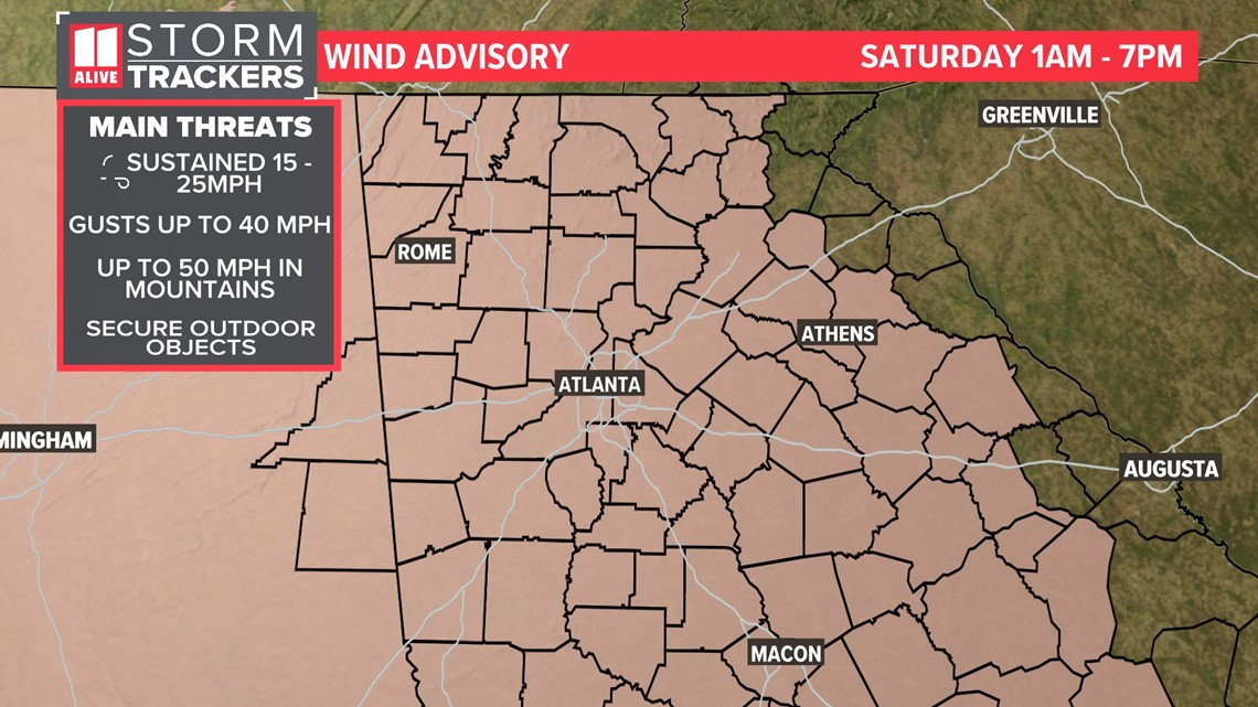
These strong winds create the "Wind Chill Factor", where it feels much colder outside than the actual temperatures are.
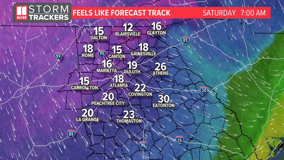
Saturday morning temperatures will be in the 30s with wind chills falling into the 10s and 20s.

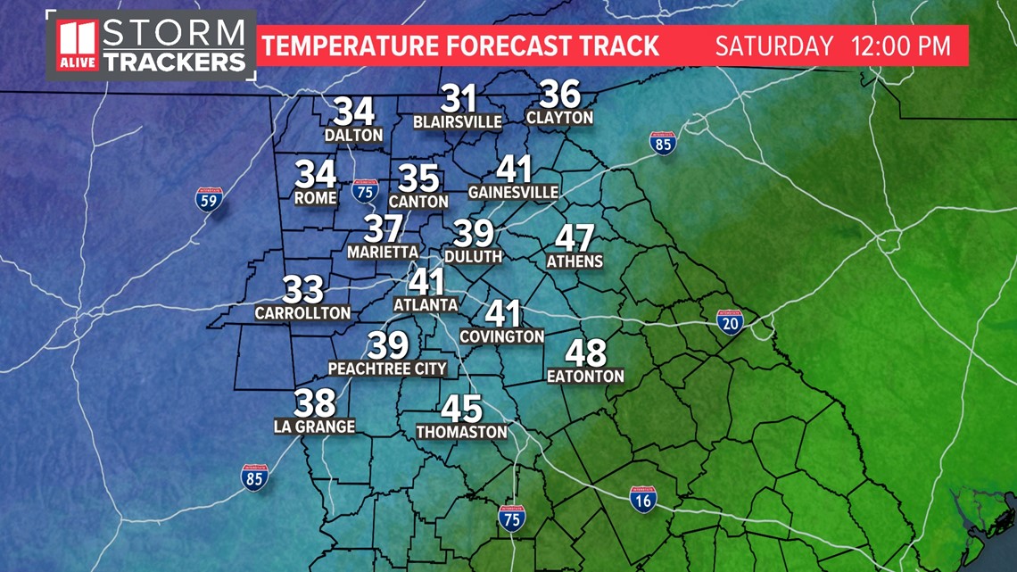
Temperatures Saturday afternoon will run in the upper 30s and low 40s, more than 20 degrees below average.

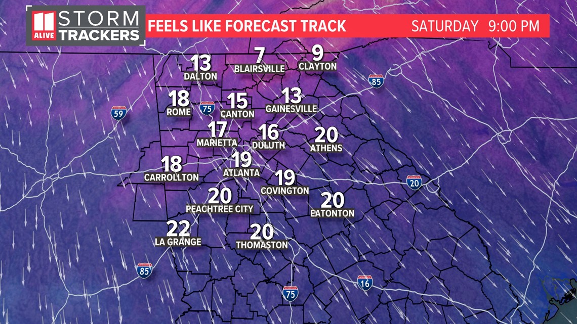
But factoring in the gusty northwest winds, the feels-like temperatures will be in the 20s Saturday afternoon in the metro with wind chills in the 10s to low 20s in the North Georgia mountains.

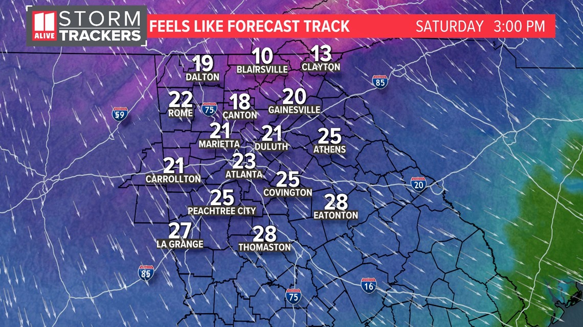
Saturday night with bring clear skies and dry air as temperatures plummet. Winds do stay gusty at the start, dropping wind chills into the 10s in the metro by 9 p.m.

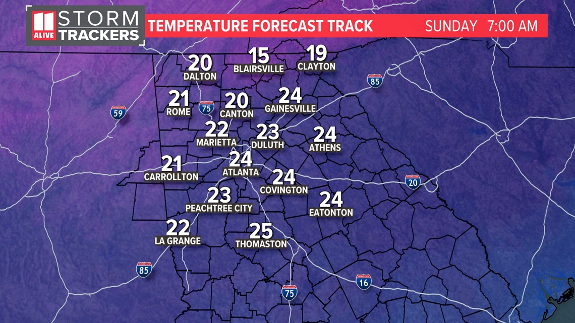
After midnight, winds should start to lighten up a bit. Temperatures drop into the low to mid 20s for overnight lows in the metro and 10s in the mountains.

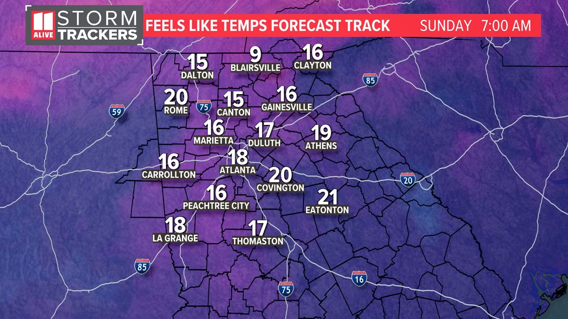
Factoring in still a light breeze, the feels-like temperatures will be in the 10s in the metro and 0s in the north Georgia mountains.

MORE FROM THE 11ALIVE STORMTRACKERS
Watch 11Alive StormTrackers Chris Holcomb, Chesley McNeil, Melissa Nord, Nicole Hartford, Andrew Wilson and Samantha Mohr on-air, on 11Alive.com, in the mobile app and streaming on 11Alive’s Roku and FireTV apps with the latest weather forecast each day.
DOWNLOAD THE 11ALIVE APP:
Set up weather notifications by clicking the Gear icon in the upper right corner of the app. Select Notification -> Notification Settings -> Severe Weather Alerts -> Toggle the Severe Weather Alerts button to the right to turn alerts on.
Send photos and videos through the app by selecting the Near Me feature on the bottom right task bar of the app and entering your information.
TEXT YOUR WEATHER PHOTOS TO US: 404-885-7600
JOIN THE 11ALIVE STORMTRACKERS FACEBOOK GROUP: Nearly 10,000 metro Atlanta and north Georgia weather enthusiasts share their weather photos every day. Click here to join the group!