ATLANTA — A round of storms producing damaging winds moved into metro Atlanta and north Georgia overnight and again early Thursday. A third round of storms moved through in the late morning and a tornado watch was in effect until the early afternoon.
The Storm Prediction Center has highlighted part of our area, including Atlanta, as a Level 3 "Enhanced" threat of severe weather.
There are school impacts in north Georgia this morning as well: Closures, opening delays in north Georgia after severe weather | List
11Alive will track any other weather developments below:
Latest updates
Thursday, May 9
1 p.m. | Gilmer County has opened a shelter for those impacted by storm damage. It's located at 1561 S Main St. in Ellijay, Georgia. Officials said pets are welcome and will be provided a kennel. For transportation, officials ask you to call (706) 889-6109.
12:53 p.m. | A tornado watch has been extended for Upson County from 12:53 p.m. to 3 p.m. Meanwhile, a tornado watch has been canceled for Fayette County, Pike County, Heard County, Rockdale County, Butts County, Lamar County, Putnam County, Morgan County, Jasper County, Greene County, Coweta County, Meriwether County, Troup County, Henry County, Newton County, Spalding County, and Clayton County.
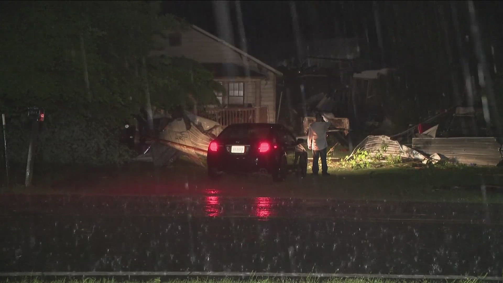
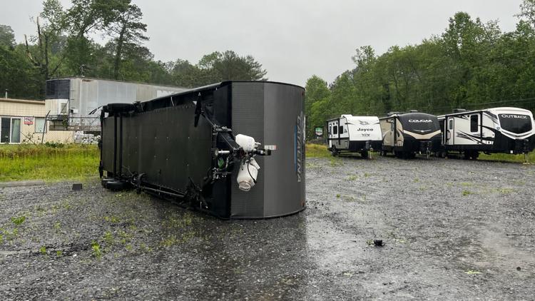
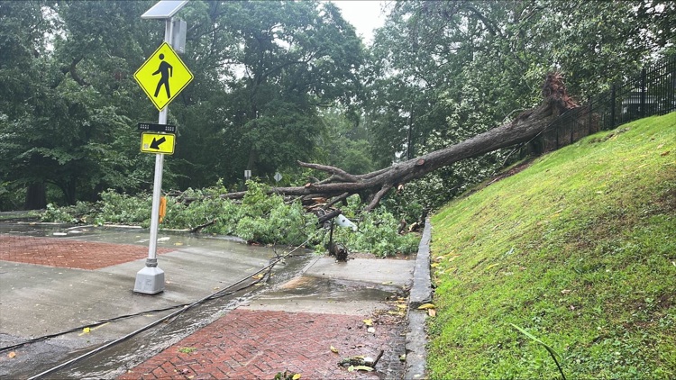
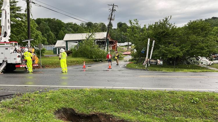
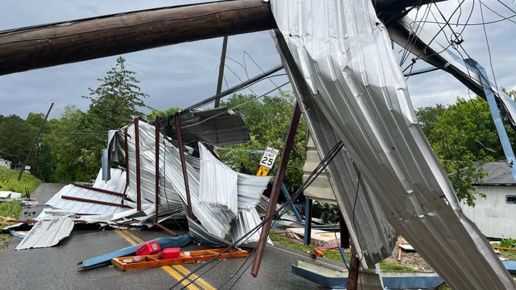
12:45 p.m. | Here's a look at the damage across metro Atlanta after storms swept through.
Photos | Storm damage across metro Atlanta, north Georgia


12:23 p.m. | A tornado watch has been canceled from 12:20 p.m. to 1 p.m. for the following counties: Madison County, Clarke County, Forsyth County, Hall County, Oconee County, Douglas County, Jackson County, DeKalb County, Cobb County, Fulton County, Walton County, Paulding County, Oglethorpe County, Banks County, Carroll County, Cherokee County, Gwinnett County, Haralson County and Barrow County.
11:33 a.m. | A ground stop is in place at Hartsfield-Jackson Atlanta International Airport until 12:45 p.m. due to storms in the area, the FAA reports.
10:35 a.m. | The tornado watch is extended in central Georgia through 5 p.m. ET. Outside of our area but involves these counties: Bleckley, Chattahoochee, Crisp, Dodge, Dooly, Emanuel, Harris, Johnson, Laurens, Macon, Marion, Montgomery, Muscogee, Pulaski, Schley, Stewart, Sumter, Talbot, Taylor, Telfair, Toombs, Treutlen, Webster, Wheeler, Wilcox.
9:53 a.m. | The tornado watch for Cleburne County and Randolph County, Alabama on Georgia's western border has been extended to 5 p.m. ET (4 p.m. CT locally).
9:23 a.m. | Something to watch for moving east into Georgia: system that just produced a tornado warning in northeast Alabama at the Georgia border:
9:09 a.m. | Still a bit of the system moving east over Alabama, a severe thunderstorm warning is in place until 9:30 a.m. ET (8:30 a.m. CT) in some of the area around Huntsville.
8:39 a.m. | Flash flood warning around Jasper and Dawsonville until 9:30 a.m.
8:32 a.m. | The severe threat that included a warning for Atlanta, north Fulton, Cobb, DeKalb, and Gwinnett has expired.
8:12 a.m. | Flash flood warning for Ellijay and Chatsworth continuing until 8:45 a.m.
8:10 a.m. | More form 11Alive Meteorologist Andrew Wilson.
8:05 a.m. | 11Alive Meteorologists Chesley McNeil and Andrew Wilson are live with an update in the video player above this story.
8:00 a.m. | Severe thunderstorm warning for Madison, Clarke, Hall, Jackson, Banks, Barrow counties until 8:45 a.m.
7:55 a.m. | The tornado watch has been canceled for several north counties: Pickens, Chattooga, Towns, Gordon, Gilmer, Fannin and Union.
7:50 a.m. | With a storm moving into the inner metro area, you can follow a live radar here.
7:44 a.m. | Severe thunderstorm warning for Fulton, DeKalb, Cobb, Gwinnett, Paulding, Bartow, Forsyth, Douglas, Polk, Cherokee and Haralson counties until 8:30 a.m.
7:34 a.m. | A severe thunderstorm warning has been issued for Gwinnett, Forsyth, Hall, Dawson and Cherokee counties until 8:15 a.m.
7:03 a.m. | There's also a severe thunderstorm warning until 7:45 a.m. for Pickens, Chattooga, Gordon, Bartow, Floyd, Gilmer, Dawson and Cherokee counties.
7:02 a.m. | Severe thunderstorm warning including Ellijay and Blue Ridge extended to 8 a.m.
7:00 a.m. | 11Alive Meteorologist Chesley McNeil is live with the latest weather info in the video player above this story.
6:48 a.m. | 11Alive will have continuing coverage online after Morning News goes off the air at 7 a.m. You will be able to watch that streaming coverage in the video player above this story.
6:33 a.m. | Severe thunderstorm warning for Chattooga, Gordon and Floyd counties until 7:15 a.m.
6:19 a.m. | Severe thunderstorm warning for Gilmer, Fannin and Union counties until 7 a.m.
6:16 a.m. | A little ways outside of our region, but Bradley County and Hamilton county in east Tennessee are under a tornado warning until 6:45 a.m.
Closer to home, the National Weather Service reports a "severe thunderstorm capable of producing a tornado" was located at 6:08 a.m. near Cohutta, 9 miles northeast of Ringgold.
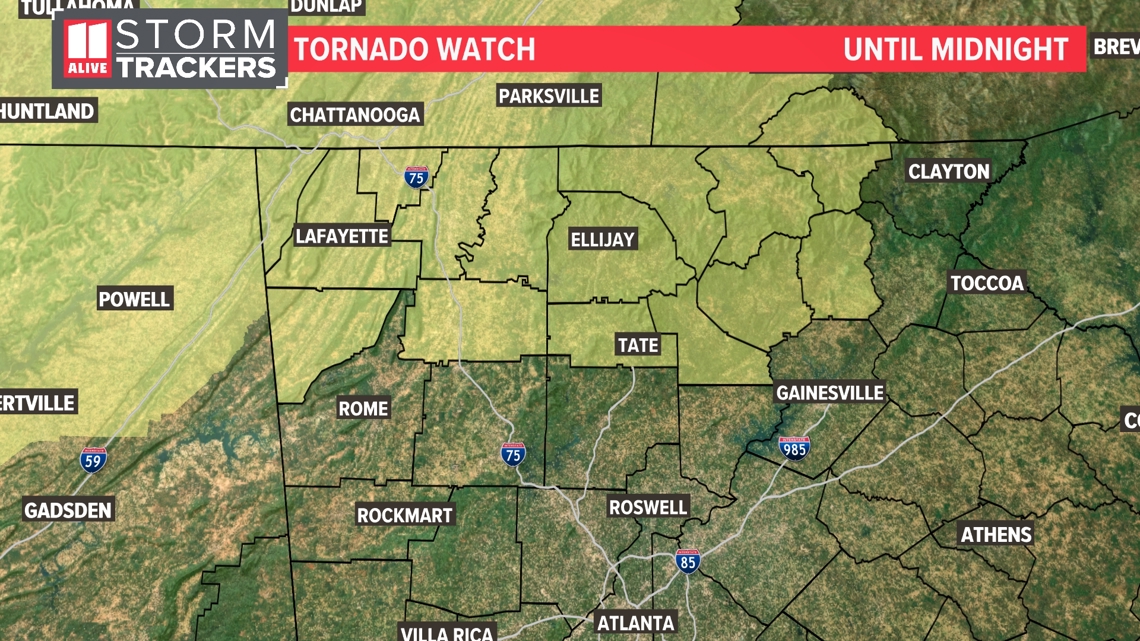
5:45 a.m. | A tornado watch has been issued until 1 p.m. for the following counties: Fulton, DeKalb, Gwinnett, Cobb, Clayton, Henry, Madison, Fayette, Towns, Bartow, Forsyth, White, Meriwether, Paulding, Union, Carroll, Haralson, Barrow, Pike, Chattooga, Hall, Rockdale, Butts, Dawson, Jackson, Lamar, Morgan, Greene, Troup, Upson, Floyd, Oglethorpe, Gordon, Clarke, Oconee, Jasper, Walton, Coweta, Pickens, Gilmer, Newton, Spalding, Cherokee, Heard, Douglas, Putnam, Fannin, Banks, Polk, Rabun, Habersham.
5:45 a.m. | A severe thunderstorm warning has been issued for Catoosa, Whitfield, walker and Dade counties until 6:45 a.m. Additionally, a tornado watch in the eastern Alabama counties of Cleburne and Randolph is in place until 10 a.m.
5:36 a.m. | The severe thunderstorm warning for Oglethorpe County has been extended to 6:15 a.m.
5:25 a.m. | North Georgia is waking up to widespread power outages. You can check them at the Georgia Power website here and the Georgia EMC website here.
5:15 a.m. | Severe thunderstorm warning issued for Clarke County and Oglethorpe county until 6 a.m.
4:52 a.m. | Flash flood warnings are in place for parts of Dawson, Gilmer, Lumpkin, Pickens, Gordon, Murray and Whitfield counties until 8:45 a.m.
4:18 a.m. | New tornado watch issued for a large stretch of the Southeast until 10 a.m.; one Georgia county included in it, our farthest northwest corner up in Dade County:
3:52 a.m. Update: Severe Thunderstorm Warning issued from the National Weather Service until 4:30 a.m. for Madison and Oglethorpe County.
1:39 a.m. Update: 11Alive's Cody Alcorn saw heavy rain, some hail and wind on I-75 Southbound near Carbondale Road (exit 326).
1:36 a.m. Update: 11Alive's Cody Alcorn continues to provide the latest information in the field. Here are pictures of some wild clouds the crew saw in Dalton.
1:27 a.m. Update: Severe thunderstorm warning issued for Chattooga County until 2:15 a.m.
1:23 a.m. Update: Severe Thunderstorm warning issued for Gordon County until 1:45 a.m.
1:20 a.m. Update: Walker County Schools posted on Facebook that it will operate on a 2-hour delay on Thursday due to the severe weather. Walker County EMA also opened a storm shelter earlier at 8 p.m. The shelter is located at Saddle Ridge School 9858 N. Hwy 27 Rock Spring, GA.
1:06 a.m. Update: 11Alive's crew in Dalton around Fourth Avenue helped the fire department carry children to their family's car. There are several ground-level units in an apartment complex being evacuated. The fire department said it's been a very busy night.
1:05 a.m. Update: Severe thunderstorm warning for Hall and Banks counties until 1:45 a.m.
1:04 a.m. Update: 11Alive's Cody Alcorn said that Dalton Fire is helping to evacuate an apartment complex.
Wednesday, May 8
12:58 a.m. Update: 11Alive's Cody Alcorn posts about flooding on Fourth Avenue in Dalton.
12:52 a.m. Update: A severe thunderstorm warning has been issued for Pickens, Gilmer and Dawson counties until 1:30 a.m. There's also a severe thunderstorm warning issued for Rabun and Habersham counties until 2 a.m.
12:44 a.m. Update: 11Alive's Cody Alcorn sees lightning off to the distance from Dalton. He's seeing a lot of flooding. Dalton Fire is responding to multiple calls, he said. The flash flooding is shutting down roads. See below for the full rundown.
12:32 a.m. Update: Severe thunderstorm issued for Hall, Dawson, White and Union counties until 1:15 a.m.
12:31 a.m. Update: 11Alive's Cody Alcorn reports of flooding in Dalton.
12:27 a.m. Update: Tornado warning issued for Chattooga County until 1:15 a.m.
12:15 a.m. Update: 11Alive's Cody Alcorn is near Dalton, giving an update on the flooding in the area. An awning collapsed at an Exxon gas station.
See some raw footage of the gas station below.
There's a lot of rain. He said there's thunder and lightning. Dalton police have said there are flooded roads.
There was also a tree down toward Dalton on S Dixie Highway.
12:10 a.m. Update: Severe thunderstorm warning for Gordon and Gilmer counties until 1 a.m.
12:02 a.m. Update: The NWS issued a flash flood warning for Gilmer County until 6 a.m.
11:58 p.m. Update: Severe thunderstorm warning for Gilmer, Fannin and Union counties until 12:45 a.m.
11:56 p.m. Update: Severe thunderstorm warning for Towns County, Fannin County and Union County until 12:45 a.m.
11:39 p.m. Update: Tornado warning for Clay County, North Carolina, until 12:30 a.m.
11:38 p.m. Update: The tornado warning for Gilmer County has been canceled.
11:26 p.m. Update: Severe thunderstorm warning until 12:30 a.m. for Clay County, North Carolina.
11:23 p.m. Update: 11Alive's Cody Alcorn said that Dalton Police posted on Facebook that a lot of roads are flooded and are asking people to stay off the roads.
11:16 p.m. Update: Tornado warning issued for Gilmer County issued. It is expected to expire at midnight. There is also a severe thunderstorm warning for Fannin and Union counties until midnight.
11:12 p.m. Update: Tornado watch issued for Hall, Banks, Rabun and Habersham counties. Also, for Clay County, North Carolina.
11:05 p.m. Update: 11Alive's Cody Alcorn is in Calhoun in Gordon County and is seeing lightning to the north of him. So far, there's not a lot of wind, and there's some raindrops, he said.
10:43 p.m. Update: Tornado warning issued for Gilmer County until 11:15 p.m.
10:27 p.m. Update: A severe thunderstorm warning for Gordon County is issued until 11:15 p.m.
9 p.m. Update: 11Alive's Chief Meteorologist Chris Holcomb gives the latest forecast and information about the tornado watch.
5:16 p.m. Update: A tornado watch has been issued for Pickens, Chattooga, Towns, Gordon, Gilmer, Fannin, Dawson, White, Union and Clay counties from 5:16 p.m. until midnight.

---
MORE FROM THE 11ALIVE STORMTRACKERS
DOWNLOAD THE 11ALIVE APP:
- Download the app on your Apple or Android device.
- Set up weather notifications by clicking the Gear icon in the upper right corner of the app. Select Notification -> Notification Settings -> Severe Weather Alerts -> Toggle the Severe Weather Alerts button to the right to turn alerts on.
- Send photos and videos through the app by selecting the Near Me feature on the bottom right taskbar of the app and entering your information.
TEXT YOUR WEATHER PHOTOS TO US: 404-885-7600
JOIN THE 11ALIVE STORMTRACKERS FACEBOOK GROUP: Nearly 10,000 metro Atlanta and north Georgia weather enthusiasts share their weather photos every day. Click here to join the group!