
ATLANTA — Strong storms are expected to move in across north Georgia today with another round coming in on Wednesday.
The main risks with this round of severe weather is damaging wind with an isolated tornado possible. Heavy rain will also be an issue at times, which may lead to localized flooding.
A flash flood warning was issued for Atlanta and Fulton County overall, as well as the surrounding metro counties of DeKalb, Cobb, Gwinnett, Clayton, Cherokee and Douglas until 8:45 p.m.
A flood warning is also in effect in north Atlanta around Peachtree Creek, in northwest Atlanta around Proctor Creek, in southeast Atlanta around Intrenchment Creek, in northeast Atlanta and DeKalb around North Fork Peachtree Creek, in Alpharetta near Big Creek, in Norcross around Crooked Creek and in north Cobb around Allatoona Creek.
A tornado watch was issued for several counties directly south of the Atlanta metro, which will be in effect until 7 p.m. tonight. Those counties include Lamar, Monroe, Jones, Baldwin, Hancock and Warren.
That watch also covers dozens of other counties in central and south Georgia.
A tornado warning was also issued for Putnam County at one point, from about 4-4:30 p.m. ET. There have been several reports of potential tornado activity in the Macon area, most notably north of downtown Macon in a potential tornado that may have crossed I-75, and a potentially significant tornado that hit Bonaire in Houston County.
Refresh this story often for the latest weather updates and download the 11Alive app on your Apple or Android device. You can watch live updates on 11Alive's YouTube channel or our Roku and FireTV apps.
Live updates
8:31 p.m. | In response to Tuesday's storms, Gov. Brian Kemp tweeted that his office has been in close contact with several of Georgia's first responder teams.
"As reports continue to come in, my family's thoughts and prayers are with all who have been impacted," he wrote.
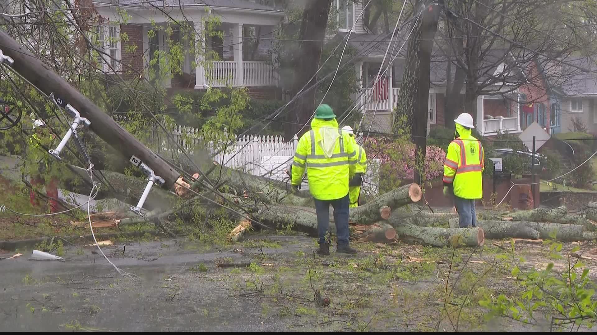
5:45 p.m. | Alex Forbes, a meteorologist at our sister station in Macon WMAZ, is sharing photos of the damage from the suspected tornadoes in that area earlier this afternoon:
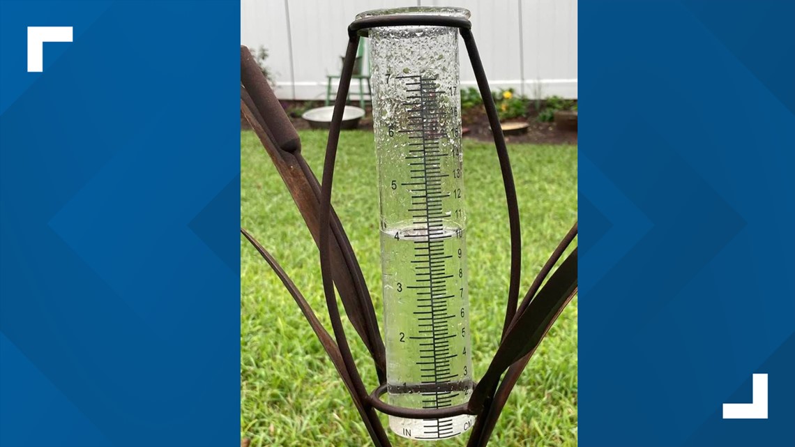
4:45 p.m. | Metro Atlanta has gotten soaked today. Want proof? Here's a photo from McDonough sent to us by one of the members of our 11Alive StormTrackers Facebook group (which you can join!):

4:30 p.m. | Most directly in metro Atlanta, the biggest effects from the weather today continue to appear to be flooding. A new flood warning has been issued now for Pew Creek in the Lawrenceville area, one of several warnings issued for creeks around metro Atlanta.
4:20 p.m. | Cherokee County's fire service reported two homes were struck by lightning this afternoon. One of those strikes sparked a fire in the attic of a home that crews were fortunately able to get under control.
4:05 p.m. | A tornado warning has been issued for Putnam County until 4:30 p.m.
That warning also includes two counties slightly outside our zone, Baldwin and Hancock.
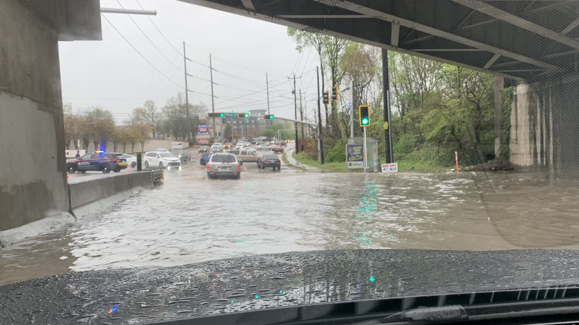
4:05 p.m. | Meanwhile, lots of reports of flooding on roads around Atlanta. We received this flooding of Piedmont Road and Miami Circle in the Lindbergh neighborhood.

3:55 p.m. | More reports of tornado activity around the Macon area, this time south of Warner Robins in Bonaire, Georgia. Sounds like it may have been a strong one. You can follow coverage of the tornado activity down that way with our sister station in Macon, WMAZ.
3:50 p.m. | Cobb County's Department of Transportation told 11Alive's Joe Ripley they're working 13 reports of flooded roads, with Huntingtonford Drive and Orchard Knob the only two closed as of now.
3:45 p.m. | Reports make it sound like a likely tornado passed through north of Macon.
3:25 p.m. | Something to keep an eye on for those if you with friends/family in Macon: Bibb County has a tornado warning in effect until 4 p.m.
Two more flood warnings in Atlanta, as well, for Peachtree Creek and Proctor Creek.
3:15 p.m. | Another creek-specific flood warning to report, this one for Crooked Creek in the Norcross area.
3:10 p.m. | The tornado watch that was issued earlier and will go until 7 p.m. was updated and made a little smaller. Troup, Meriwether and Pike counties are no longer included in the zone.
Separately, a flood warning was issued for around Big Creek in Alpharetta.
3:05 p.m. | A flood warning has been issued for around North Fork Peachtree Creek in northeast Atlanta and DeKalb County.
3:00 p.m. | A flood warning has been issued for around Intrenchment Creek in southeast Atlanta.
2:50 p.m. | There may have been a possible tornado down in southwest Georgia. It was reported in Stewart County, which is about 40 minutes south of Columbus.
2:47 p.m. | Flash flood warning issued for much of metro Atlanta - Fulton, DeKalb, Cobb, Gwinnett, Clayton, Cherokee and Douglas counties until 8:45 p.m.
2:45 p.m. | Keep an eye out for this on I-20 in DeKalb:
2:40 p.m. | A flood warning has been issued for the area around Allatoona Creek in north Cobb County.
2:30 p.m. | Outside our zone, but there's a tornado warning for Marion, Taylor and Talbot counties until 3 p.m.
2:25 p.m. | Severe Thunderstorm Warning issued for Lamar and Upson counties until 3 p.m., as well as Marion, Talbot and Taylor counties a little farther out.
2:15 p.m. | Again, as far as severe weather goes, it's been quiet up our way. But there have been tornado warnings down in south Georgia. Chattahoochee, Marion and Stewart Counties have all had tornado warnings in the last hour or so.
1:45 p.m. | Here's a cool timelapse a viewer sent us from earlier today as the storms began rolling into Atlanta:

1:35 p.m. | A tree caused a power outage affecting more than 670 customers mostly off Peachtree Hills Avenue in the Peachtree Hills neighborhood. Georgia Power doesn't expect power restored over there until 9 p.m. tonight.
1:20 p.m. | Well outside our area, but Georgia's first severe thunderstorm warning of the afternoon was issued in Clay County, west of Albany on the Alabama border. That's in effect until 2:15 p.m. ET.
1:10 p.m. | Some heavy rain and lightning moving through parts of the metro, but no official warnings or anything like that.
12:55 p.m. | 11Alive Chief Meteorologist Chris Holcomb and Andrew Wilson will be providing a live update on developments in about five minutes, which we will be streaming in the video player above this story.
12:50 p.m. | We've gotten word that lightning struck a home in McDonough earlier this morning and caused a small fire. Fortunately, officials said the damage was contained to the home's attic.
12:40 p.m. | Another tornado warning for our friends around Auburn, with Lee County, Alabama, in a new warning until 1:15 p.m. ET (12:15 p.m. CT locally).
12:20 p.m. | This is a little outside our range, but there is a tornado warning in effect for Lee and Tallapoosa counties in eastern Alabama until 1 p.m. ET (locally in those counties, that's 12 p.m. CT).
12:05 p.m. | There's the tornado watch for central and south Georgia. Includes as far up as LaGrange and several other counties south of the Atlanta metro - Troup, Meriwether, Pike, Lamar, Monroe, Jones, Baldwin, Hancock and Warren among them.
12:00 p.m. | We could shortly see a tornado watch issued for south and parts of central Georgia:
11:20 a.m. | Regardless of if the weather rises to any severe warnings, one thing to remember is a lot of rain in metro Atlanta usually means messy conditions on the roads. Follow 11Alive Traffic Tracker Crash Clark for any updates there:
11:00 a.m. | Still a lot of rain coming in from the southwest out of Alabama, which will continue for several hours, but nothing in the way of severe weather. A small portion of Henry County was included in a special weather statement advisory that expired at 11 a.m., but that's about it so far.
10:30 a.m. | Obviously the heavy rains and thunderclaps are beginning to pick up in the metro. No severe weather warnings expected yet, though we've seen reports of strong thunderstorms already south of the Atlanta metro in areas like Monroe, Lamar and Upson counties, as well as a report of hail in Lamar.
10:00 a.m. | You can watch 11Alive Meteorologist Chesley McNeil's update in the video player above this story shortly.
9:00 a.m. | We're expecting the storms to start arriving in the inner metro area a little before noon today. You can see a full timeline of what we're expecting here and 11Alive Meteorologist will be offering a live update of what to look out for at 10 a.m. this morning.
MORE FROM THE 11ALIVE STORMTRACKERS
DOWNLOAD THE 11ALIVE APP:
Set up weather notifications by clicking the Gear icon in the upper right corner of the app. Select Notification -> Notification Settings -> Severe Weather Alerts -> Toggle the Severe Weather Alerts button to the right to turn alerts on.
Send photos and videos through the app by selecting the Near Me feature on the bottom right task bar of the app and entering your information.
TEXT YOUR WEATHER PHOTOS TO US: 404-885-7600
JOIN THE 11ALIVE STORMTRACKERS FACEBOOK GROUP: Nearly 10,000 metro Atlanta and north Georgia weather enthusiasts share their weather photos every day. Click here to join the group!